Every year, the rainy season in Sierra Leone comes with its usual ferocity and destruction of lives and property. And every year, the response from government and society remains the same. Such a business-as-usual attitude and reckless environmental stewardship must change if Freetown is to remain a viable community, with people living and working sustainably alongside the city’s ecosystem and landscape. The causes of Freetown’s annual flooding and disaster epidemic are multidimensional and complex. The city has essentially become a massive slum, and creating a viable and sustainable city of Freetown is the singular most important challenge the nation of Sierra Leone faces. We cannot fix Sierra Leone without fixing Freetown, and to fix Freetown requires an active, integrated, multi-sectoral, collaborative transformational process of decolonising and decentralising the capital.
Flooding in Freetown is not just about rains, garbage in the streets, poor drainages, hillside constrictions, poor people squatting in disaster-prone areas, or the construction of more low-cost housing. It is about a myriad of forces: environmental, social, economic, geological, geomorphological, land use planning, engineering, and above all, coordinated radical, bold, technically sound, and transformational policies.
The news story scripts for flooding and rain-related disasters in Freetown have been almost the same for the last 5-10 years. Each time, we simply react to the looming disaster, hold emergency donor meetings, do some talk, make some noise about solving it, generate some funds, get NGOs in it, and so on, but there is nothing to show for it in the end. Hence, the long history of unlearnt lessons about flooding, disaster management, and transformational urban planning continues. The future of Freetown as a sustainable, livable city will require a radical transformational shift in its political ecology.
Water resource management is central to that radical shift in our political ecology. Water in Freetown is a blessing; plenty of it in the rains, a curse from the risks of flooding, and a stress agent from lack of it in the dry season. Climate change will undoubtedly cause more shifts in the patterns and intensity of rainfall, with potentially devastating consequences. Hence, there is a dire for proper environmental stewardship and climate change adaptation actions, despite Sierra Leone’s negligible to infinitesimal contributions to global carbon emissions.
REVISITING THE PAST TO UNDERSTAND THE PRESENT
To understand Freetown’s present and challenges, one must delve into the past. Freetown’s centrality as a nexus for business and political administration dates back to its founding in 1792, and some historians state it dates back to the Province of Freedom in 1787. In 1787, about 400 enslaved Africans from the Americas, the Caribbean, and beyond were sent to re-settle in Freetown on land purchased from the local Temne Chief. They established the Province of Freedom (1787- 1789).
Eventually, the Freetown Colony, led by the British, was born out of the Province of Freedom between 1792 and 1808. From 1808 to 1951, Freetown operated as a separate colony entity from the rest of the country, known as the protectorate. This separation also meant different political systems constitutionally defined each entity. The Freetown colony was essentially Sierra Leone, serving as the administrative headquarters for British West Africa.
Despite having the coastal waters added to the colony, Freetown’s proper dimensions were largely from Ferry Junction (Up Gun area) to Congo Cross. At independence in 1961, apart from the so-called formal integration of Freetown with the protectorate and adopting a single constitution, the colonial structure was largely maintained.
Nothing was done to completely decolonize the colonial administrative structure, decentralize from Freetown, or create formal urban planning for the future growth of the city. Hence, the present-day problems of Freetown emanated from Independence and exacerbated over time.
In hindsight, our founding leaders were very busy consolidating power from the British and did not put a lot of thought into the geographical, geological, and environmental constraints of Freetown, which would eventually become the heart of the country.
The British encountered some of these constraints and sought ways to address them. For instance, as early as 1916, much of the forested Peninsula area was declared protected zones due to the risk of landslides or flooding.
THE NATURAL AND HUMAN FACTORS DRIVING THE FLOOD EPIDEMIC
So, what are the underlying proximate and ultimate factors driving flooding and disaster risk in Freetown? It may not look obvious, but geography is an important aspect and major constraint on the expansion of Freetown. The city is virtually a tiny strip of lowland mass sandwiched by the Atlantic Ocean and Peninsula mountains. This means that geographical expansion is towards the coastal ocean areas or the mountains. Any form of human or land use activity on either end poses many environmental risks, which I will delve into later.
Another aspect of geography that becomes important in the context of Freetown is geomorphology, which makes up the beautiful mountains and steep slopes around the city. These steep mountain slopes around Freetown are a blessing in their natural state but, in the case of Freetown, a curse due to unplanned, uncontrolled land use activities.
Freetown, as a city, records the highest rainfall in West Africa, thanks in part to the high altitudes that force westerly winds to rise, form clouds and rain at the windward end of the mountains, something geographers refer to as relief rain. Well-rainwater also moves down slopes much faster, and the runoff is severely enhanced in slopes where land cover is depleted. By contrast, runoff is significantly reduced in the natural vegetated state due to greater rates of soil infiltration.
In terms of mass flow balance, the rate of runoff far exceeds the rate of soil infiltration due to indiscriminate land cover clearance in the peninsular, hence risk of flooding downhill is extremely high. Another highly important factor in the discussion of geomorphology, slopes, and mass flow is geology. The slopes in and around Freetown are still evolving and unstable geologically; therefore, the risks of mudslides or landslides are high with land use activities that expose the topsoil.
Human activities are a major factor in the removal of protective vegetation cover and land cover degradation of mountain slopes in and around Freetown. Interestingly, human land use degradation of the protective mangrove swamps in the coastal areas of Freetown is even alarming. A sea level rise precipitated by climate change could be hazardous to low-lying coastal locations of Freetown without mangrove vegetation cover.
Having discussed the human factors above, let us delve deeper into Freetown and the surrounding Peninsular areas. How did we get into this vulnerable situation with disasters in Freetown? Who bears responsibility for the present situation? How has the political economy of the state shaped the present political ecology? What courses of action can be taken now to mitigate the situation?
To attempt to answer these questions, we must delve back into Independence in 1961. Freetown as a city was a colonial construct that never planned for the ensuing post-independence population boom.
Rapid population growth accounts for the destabilizing effect of human factors on Freetown.
Based on census data, Freetown’s urban population was roughly 120,000 in 1963. From 1963 to 2015, the human population increased 8—to 10-fold, accounting now for over 20% of the country’s population.
Interestingly, the sharpest rise in the city’s population occurred from 1974 to 1985, not during the 11-year rebel war (1991-2002), as conventional wisdom would expect. The sharp increase in population between 1974 and 1985 may likely have resulted from the early effects of neoliberal economic policies, structural adjustments, globalization, corruption, and a downward turn in the economy.
Again, post-war Freetown’s population growth between 2004 and 2015 equals the period 1985 to 2004. Freetown’s urban and rural population, now well over 2 million, continues to boom as rural-to-urban migration continues. In the 58 years since Independence, Freetown remains the central locus for political and business administration in the country. This is so despite the formation of local councils and attempts to decentralize the country through the Local Government Act of 2004.
The net effect of the high population growth has been significant ecological depletion and land degradation due to uncontrolled, unplanned, and indiscriminate human land use activities in and around Freetown. The predominant driver in the ecosystem destruction and subsequent land degradation has been unplanned informal housing settlements in mountain areas or low-lying coastal mangrove areas. These unplanned housing settlements account for over 50 percent of Greater Freetown.
The most planned part of the city runs from Up Gun to Congo Cross, which interestingly were the city limits of colonial Freetown. This goes against the grain of urbanization in most parts of the world, where the old portion of cities are unplanned, and newer expansions are highly planned.
Apart from the rise in informal housing construction, the additional human population in and around Freetown has meant the depletion of valuable forest products for timber, firewood, and charcoal for cooking, sand mining activities in coastal areas for building and clearing mangrove forests in coastal regions for firewood, charcoal, or housing construction.
These activities, individually or combined, contribute to ecological hazards and the depletion of valuable biodiversity, with disastrous consequences for human and animal populations.
Deforestation of land cover in mountain tops and slopes removes the protective barrier of plants over topsoil, increasing runoff, decreasing soil infiltration, reducing water retention in soils, and reducing evapotranspiration from the depletion of the watershed. This results in a greater likelihood of flooding, mass flow (soil, debris, and rocks), mudslides or landslides in the rains.
On the other hand, there is a greater risk of drought and water scarcity in the dries due to the significant depletion of trees in the watershed. The decrease in evapotranspiration activities may also impact the amount and distribution of rain. The convergence of environmental degradation and climate change may significantly impact precipitation and temperature patterns in Freetown.
For instance, although recent flash floods or landslides in Freetown could be attributed to higher-than-normal rainfall, the rainfall pattern has been largely uneven in the last few years. The rainy season has become shorter, with intense rains during the last few months that are more disastrous due to manmade activities such as land degradation.
Sand mining along coastal beaches and clearing of mangrove vegetation along coastal tidal flats areas for construction projects, firewood, or charcoal have been equally damaging to the ecological space.
Apart from the loss of valuable biodiversity and its impact on animals, including fish and migratory birds, the removal of the protective barrier of mangrove forests and coastal sand has disastrous consequences from flooding associated with sea level rise.
The coastal low-lying areas of Freetown are considered particularly prone to climate change-related disasters linked to sea level rise.
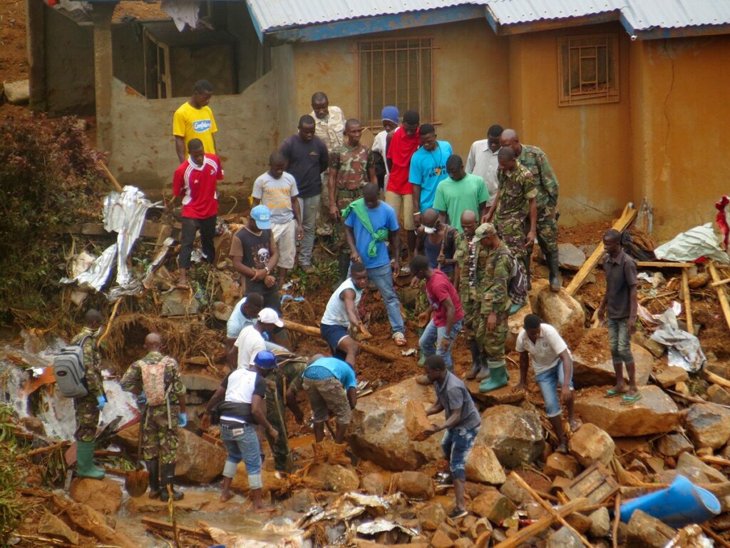
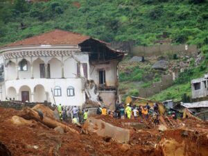
Overall, the consequences of our indiscriminate human actions in Freetown have been significantly more flooding than in previous years, mud and debris slides, and landslides, as in the deadly August 2017 episode that killed over a thousand, displaced thousands of residents and destroyed over 900 homes.
Although unusually heavy rains triggered the August 2017 disaster, the underlying factors were essentially human activities leading to land degradation that impacted geology and slope stability.
The economic cost of disasters and post-disaster recovery is tremendous. Equally, the cost to animal health, wildlife, and biodiversity from rapid ecological destruction is huge, and I will not fully delve into this area here.
DISSECTING THE ROOT CAUSES OF THE PROBLEM
Although human population growth may appear to be an important driver of the flood epidemic in Freetown, the underlying factors are even more complex. It is a question of who bears the most responsibility here? Is it the people or lack of foresight and political will by successive governments?
It can be argued that the biggest and most significant factor in the recent spate of floods in Freetown has been the failure of successive government governments to implement a radical transformation plan for the city.
The elitist tendency among many has been to blame the people, heavy rains or climate change, masking their inadequacies in viable transformational plans. If we even accept the heavy rains as a factor, the rains have been intense, but the overall duration of the rainy season has gotten shorter.
As discussed above, these shorter durations of rain have lent themselves to water stress or drought in the dry season. The truth lies in our inability as a nation since Independence to develop a sound blueprint urban plan that meets the needs of the present and future growth of the city.
Instead, the only progress beyond the colonial limits of the city has been uncontrolled sprawl, unplanned buildings in protected forest and mountain slope regions, and unplanned settlements with no access roads, a market, a hospital, or basic services for the community.
The colonial political economy of forest ecology and land management, which prevents community ownership, is still in force.
During the colonial period, the British administration declared much of the forested areas, including the Freetown Peninsula, protected. In theory, this was good, but in practice, it was a hypocritical ploy to prevent indigenes or communities from owning their resources, thereby giving British businessmen unfettered access to timber and forest products.
Today, this arrangement of forest management out of the hands of the community members and operated by the government, favoring big business and foreign entities, continues. The indigenous community members’ ownership and management of their lands and forest products have not occurred.
Hence, communities marginalised from their forests see less value in forest products and resource conservation. What has happened is the commodification of the land and forest products, which goes against community conservation practices.
Equally so has been the failure to decentralize the political and economic administration from Freetown. Even the most important government offices within the city operate within old buildings created during the colonial period, and successive governments have failed to upgrade them to meet the current needs of an open government workspace atmosphere. Interestingly, the lack of a radical transformation blueprint plan is worsened by several terrible policies, corrupt practices, and events within the country’s political economy that have hurt rather than helped the city.
First, there are the neoliberal economic policies of the West that replaced colonialism’s political grip. We may have gained political “Independence” in 1961, but economic independence is far from it. Through neocolonialism and economic policies, the West has maintained unfettered access to our resources.
The neoliberal economic policies of globalization and monetary policies promoted by the IMF, World Bank, and other international donors have deepened poverty in rural communities, displaced farmers from the land, as local small-scale farming is no longer profitable, destroyed local production of any sort, and made Sierra Leone an import-dependent economy. This, in turn, has spurned a rural-to-urban migration and population boom in the city.
In Sierra Leone, this massive process of urban flight began in the early 1970s with President Siaka Stevens’s bad economic policies and reached a peak by 1985. The ensuing economic crisis and poverty deepened with Stevens’s APC government and allegations of widespread corruption, nepotism, decadence, and strife.
Because of this economic downturn, people from rural areas congested Freetown not from choice but from despair. Many of these rural migrants, without the economic means to live in the city, turned to shanty settlements in coastal areas or mountain slopes and, as such, gave rise to massive slum settlements around the city.
By 1990, Sierra Leoneans were lining up for food rations under President Joseph Saidu Momoh’s Government. It was the era of “toe line” for all things necessary, and people referenced the hardship as an additional trigger for the war. The war and total state collapse from 1990 to 2002 simply further accelerated the land degradation of Freetown.
Due to the war and restrictions on movement, people residing in and around Freetown turned to the forests for wood and charcoal. Displaced people from communities in rural Sierra Leone established squatter settlements along the coastal areas and mountain slopes. The land cover in rich forest areas like the Fourah Bay College Botanical Gardens was depleted.
The construction of the British IMATT military installation and, subsequently, the United States Embassy further fueled unregulated housing construction in protected forest-reserved areas of Regent, Charlotte, and Sugarloaf.
The heavy commodification of the land continued post-war, exacerbated by strong economic remittances by Sierra Leoneans displaced in the diaspora and high corruption at private and public institutions.
The war and post-war recovery provided ample opportunity for huge investments and goodwill donations from the international community. These funds often meant to support recovery efforts of various sorts in the country, ended up in unscrupulous, corrupt hands. The end result was mansions on the mountains, slopes, and coastal mangrove areas, which led to further pillage of the land, weakening slopes and enhancing the city’s disaster vulnerability.
A second factor has been the lack of coordination in policies and enforcement by the government agencies that deal with land, environment and forest management in Sierra Leone. The Ministry of Lands, Housing and Environment, the Ministry of Agriculture and Forestry (MAFF), the Environmental Protection Agency (EPASL), the National Protected Area Authority (NPAA), and the Water Resources Ministry all operate with certain degrees of mandate, but do not seem to speak to one another or coordinate efforts.
Nobody wants to take on the blame or responsibility for land cover degradation and unregulated land use in and around Freetown. For example, MAFF wants to protect the forests, while the Ministry of Lands wants to sell them. The EPA will say it doesn’t have the mandate to enforce protection, and that’s the domain of the NPAA.
Significantly, there has been a huge rise in informal settlements across the city, which begs the question of what the planning ministry is doing. It seems there is not a singular urban plan for the city with blueprints for buildings, recreational areas, road networks, sewage disposal, water resources, public restrooms, and so on. This lack of a singular transformational land and forest ecology management plan has cost the city and people dearly, with disastrous consequences such as the August 2017 landslide.
A third and decisive factor that goes with the second factor is corruption in land and forest ecology management. Everyone who has built in protected areas of highland forest or coastal areas has documents and paperwork to prove ownership.
However, successive governments have not prosecuted any individual. The corruption by public servants in these agencies that oversee lands, environment, housing, and forestry cannot be disassociated from poor wages and labor conditions.
The average monthly salary of a forest ranger is less than 1500 Leones. This puts many of them in a precarious position and makes them prone to taking bribes or engaging in illicit activities to make ends meet. I have a feeling a similar situation applies to those at the Ministry of Lands, with the unregulated and indiscriminate selling of lands in protected zones.
A fourth factor that has enhanced flooding in the city has also been the poor construction of roads and drainages. Stormwater runoff moves faster on paved asphalt or concrete roads than on unpaved surfaces.
In Freetown, heavy runoff from bare surface-covered hills meets paved asphalt or concrete roads with poor drainage. The runoff also erodes exposed topsoil and brings it down, clogging drainages.
Hence, it is extremely difficult to control stormwater downhill. With enough paved asphalt or concrete surfaces, it speeds down to the coast. The coastal areas of Kroo Bay, Susan’s Bay, Wellington, and others are severely impacted by such flood waters.
PROGNOSIS – WHERE DO WE GO FROM HERE?
Overall, the biggest malaise regarding environmental degradation and flood mitigation in Freetown and Sierra Leone has been our history of unlearnt lessons. Since independence, we have had ample opportunities, as a nation, to correct the wrongs, yet we have failed to take radically transformative measures to fix Freetown.
This perennial failure to learn from lessons of the past has been the case nationally, from war, Ebola to the deadly August 2017 landslide. At every turn or moment when transformational action should take place, we have turned to half-baked small, minded measures addressing the parts and not the sum of the parts of the problem.
For instance, we embark on cleaning drainages and clearing trash as a quick fix for a problem that is gargantuan and complex, as discussed above. We have often turned to international donors, non-profit organizations, and exogenous ideas or solutions to an endogenous problem.
We cannot transform Freetown from the backseat of external drivers. What is needed are innovative thinking, locally driven and utilizing natural resources of the nation to transform the most important settlement of the country.
A sustainable, viable, and green Freetown can drive significant economic growth in surrounding regions and the country. The process of transforming the city and surroundings can begin through diverse and inclusive community engagements at all levels, functions, and disciplines to produce a product that addresses current issues and has a sustainable outlook for the future.
SO, HOW DO WE MITIGATE THE FLOOD EPIDEMIC OF FREETOWN AND CREATE A SUSTAINABLE GREEN CITY?
First, we need a transformational urban development blueprint based on community engagements or inputs at levels, functions, and disciplines. This blueprint should radically address some of the vexing present-day challenges and provide a future sustainable outlook for Freetown.
This should be a multidisciplinary, interdisciplinary, transdisciplinary effort that brings together engineers, architects, urban planners, geographers, geologists, environmental scientists, forest ecologists, entrepreneurs, water resources, hydrogeologists, public health, social welfare, etc.
It should ideally address the vexing issues of flooding, landslides, zoning codes, protected areas, sanitation and public health, congestion, transportation networks, housing, rehabilitation of slum areas, recreational park development, foot and bike paths, forest ecology and green space development, urban agriculture, water resource management, waste management, and so on.
Herein, the Universities have a great role in driving the ideas for the multi-sectoral Ministries, Departments and Agencies (MDAs), and Freetown City Council associated with flood mitigation and environmental stewardship.
To ensure the implementation and enforcement of policies, the blueprint to be adopted must be endorsed by community members, stakeholders, and all political parties.
Second, significant efforts should be directed towards decentralising political administration and creating new growth centres of economic activity. For instance, an urban plan of Waterloo, Newton, Masiaka, and Lungi on the axis from Freetown should be initiated; significant administrative centres should be moved to these locations, and light rail transit and bus services should be created from Masiaka through Waterloo to Freetown. Lungi could be connected via improved 24-hour ferry services that shuttle passengers to Freetown and back. This will also enhance the economic potential of Lungi beyond simply the airport.
Additionally, water transport that links Aberdeen to the downtown Central Business District (CBD), Wellington to the CBD, and the CBD to Lungi and various points around the peninsula will ease traffic congestion and thereby minimize the need for people to live within Freetown.
Third, building on the city blueprint, we must enforce zoning codes and clearly demarcate and designate a green belt in disaster-prone areas. This will entail engaging geologists, geographers, ecologists, civil engineers, urban planners, hydrogeologists, and other disciplines to create an updated hazard profile and risk assessments for the city and surrounding peninsula areas. Such hazard mapping and risk assessments could be undertaken by multidisciplinary teams of university students during the rains.
Existing buildings in areas demarcated as disaster-prone should be demolished and relocated to other regions. An active afforestation program of the green belt areas should follow tree planting and allow secondary regrowth of native vegetation.
Communities below the greenbelt must also engage in active tree planting, planting grass, and developing green spaces that slow down runoff and enhance infiltration. This green space development should be an integral part of creating a green cityscape around Freetown. Mangrove areas of coastal Freetown should be repopulated with mangrove forests.
Fourth, we can create a series of reservoirs and dam systems in catchments areas and slopes along the runoff flow, wherein we capture and store excess water for utility in the dry season..
As a city that records the highest rainfall in the subregion, there is no reason why we should have periods of drought in the dry season. Each household should be encouraged to have a rainwater harvesting or capture system, which can be created at the community level using simple compressed clay brick or local soil.
This allows us to turn something of a disadvantage into an advantage for communities. The excess water stored in communities could feed into urban agriculture and vegetable gardening for home consumption or market.
Fifth, the political economy of forest ecology management in the Freetown Peninsula and nationally should be radically reformed towards a community-based natural resource management system. Forests are an important source of livelihood for residents and can be an essential economic avenue for poverty alleviation.
The Freetown Peninsula has over 70 recorded medicinal plant species and several others of economic importance. A sustainable community-based management system can provide local livelihoods from forest products and, at the same time, enable the conservation of the forest ecosystem.
As in the colonial system, the current centralized system of forest management by the Ministry of the Environment continues to prohibit locals from the full utilization of their forest resources. Again, as in the colonial era, the argument to prohibit locals from utilization of forest resources is that they are responsible for deforestation.
Yet, under the watch of the Ministry of Environment, Agriculture, and Lands, we have seen massive land encroachment for housing developments and a complete failure of the governance system. No major institutions (Ministry of Agriculture, Ministry of Lands, Ministry of Environment, EPASL, NPAA, Freetown City Council (FCC) have taken responsibility for the land encroachments and failed governance in Freetown. Rather, poor residents of these communities, who are victims of the failed governance systems, are blamed for deforestation.
Therefore, sustainable forest management must consider a decentralized community-based natural resource management system and reform of the governance system. Moreover, the mandates of the various institutions (Ministries of Lands, Agriculture, Environment, EPASL, NPAA, FCC) charged with land, forest, and conservation management should be better coordinated and clarified. The Ministry of Lands, Housing, Country Planning, and Environment should be dissolved and absorbed into Agriculture, EPASL, with housing and planning merged with MOPED.
Sixth, tackling the city’s drainage issues should include technically sound civil and environmental engineering designs in road construction. Moreover, it must be backed by a solid understanding of hydrogeology and the mass flow of runoff in specific locations to minimize the effects of stormwater on roads. Areas prone to flooding could be provided with depth and breadth drainages to accommodate stormwater. Additionally, sidewalks could be made broad with a layer of grass in between to slow down stormwater runoff into drainages.
Seventh, going back to the blueprint, zoning of the entire Freetown Peninsular should be undertaken and zoning codes enforced with severe penalties for defaulters. I hope that merging housing with urban planning within MOPED will ensure proper urban planning and enforcement of building codes across the city.
A robust geographical information system (GIS) mapping of the city could lead to a proper urban plan with grids for residential, commercial and lots allocated for social services in communities.
Every town lot within the city and surrounding area could be on the grid, with access roads defined and a road network established. Housing schemes could be established that promote community low-cost housing and restrict the number of town lots an individual can own for family residence. Building interior and exterior architectural designs could be improved to maximize utility in small spaces and remove the current need for large amounts of land with massive structures for a small family residence.
Eight, an improved GIS mapping should also enable the setting up city-wide disaster and flood alarms in each municipality. Based on the city-wide blueprint mapping, spatial data on geology, geomorphology, rainfall, and land cover could be integrated into a GIS system and establish a threshold for flooding or landslides. For example, rainfall beyond the normal threshold should trigger an alarm locally (a large horn or sound) in the community, which is also linked to radio and television. Such triggers will allow community members to seek shelter or move to higher ground, minimizing human casualties.
Finally, better wages, salaries, and service conditions for civil servants entrusted with oversight or governance will minimize corruption and enhance the enforcement of laws or regulations.
About The Author

Alhaji Umar N'jai
Alhaji Umar N’jai is a Senior Scientist, Associate Professor, Lecturer, Panafrican Scholar, Founder and Chief Strategist of Project 1808, Inc. and Koinadugu College and Freelance writer ‘Roaming in the Mountains of Kabala Republic’.